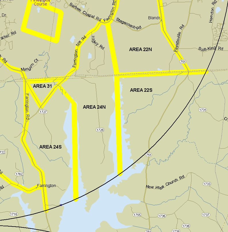
22S. Southeast area. NC 751 from Fayetteville Rd. (1118) south to count circle, west to midstream New Hope Creek/Jordan Lake, north to Chatham Co. line; county line east to count circle. Notes: Includes game lands accessible from 751 (parking lot just north of the bridge over Jordan Lake).
Ebird hotspots:
Jordan Game Land---(751 bridge) Northeast Creek
Jordan Lake--New Hope Creek arm (Chatham Co)
24N. Old Hope Valley Farm Rd. area. Peninsula in Jordan Lake from center of New Hope Cr. on east to center of Morgan Cr. on west and from count circle north to Farrington Mill Rd (SR 1109/1726). Notes: Includes Kepley Road. See Old Hope Valley Farm Road for ideas on where to go.
Ebird hotspots:
Transis Camp Rd.--Hope Valley Experimental Forest
Jordan Game Land--Mason Point Peninsula
Jordan Lake--New Hope Creek arm (Chatham Co)
Jordan Lake--New Hope Creek arm (Durham Co)
Jordan Lake--Morgan Creek arm (seasonal mudflats)
24S. Cub Creek area. Bounded on north by Farrington Mill Rd. (SR 1726), east by center of Morgan Creek, south by count circle, west by Farrington Road (1008). Includes Farrington Mill Rd. bridge over Morgan Creek. Count both sides of 1008. Notes: There is an extensive swampy area at Cub Creek east of Farrington Road which has a large Great Blue Heron colony.
Ebird hotspot:
Jordan Game Land--Cub Creek
Notes on covering 24S by Haven Wiley:
I park at the junction of Mt Carmel Church Road and Old Farrington Road 35.8456, -79.0260 -- plenty of room. Then it's bushwhacking across the power line easement (usually a mess) and then along the left (northeastern) side of Cub Creek, all the way to the Morgan Creek arm of Jordan Lake. In the lower parts of Cub Creek there are some major curves, so a compass might help to cut across to the lake (it might be a good idea to study the satellite image to see where you want to go).
Area 24S also includes quite a lot of Mt Carmel Church Road (which has little to offer that I can find) and also Whippoorwill Lane south from Old Farrington (35.8522, -79.0187). Lots of private property here, but the power line easement headed northeastward reaches a high bluff overlooking the Morgan Creek bottoms (35.85095, -79.0091). The easement has birds, but I have yet to find anything super interesting there.
From the bluff you can bushwhack down the slope southeastward and southward, probably most of the way to the upper end of the arm of Jordan Lake (I have never made it all the way, though). When there are mud flats at the upper end of this arm of the lake, they are easier to reach from Mason Neck to the east, the route birders usually take.
The most interesting part of 24S is the extensive marsh in the beaver impoundments on Cub Creek once you cross the powerline easement. There must be rails in there and possibly other interesting birds. Last December I had Virginia Rails answer my playbacks in December when scouting for the Xmas count. At this time of year it would be a great place for King Rails, I would bet. And you never know what might hang out in the secluded arm of Jordan Lake at the mouth of Cub Creek.
Revised 5/6/2019 cwcook@duke.edu